Snaefellsnes Peninsula Road Trip Itinerary
This post may contain affiliate links.

Often referred to as “Iceland in Miniature”, the Snaefellsnes Peninsula is a geologically diverse region in western Iceland that features the country’s full range of natural wonders.
Lava fields, volcanoes, glaciers, sea stacks, black sand beaches, and seaside villages: all of it condensed into a (relatively) small 90-kilometer long peninsula just a few hours north of Reykjavik. If you only have a few days for a road trip in Iceland, we highly recommend checking out the Snaefellsnes Peninsula.
Getting to the Snaefellsnes Peninsula
From Reykjavik
Heading north on Route 1, you will either need to drive around Hvalfjörður fjord or go through the tunnel. Continue following Route 1 until you get to Borgarnes then turn onto Route 54, which will lead you onto the peninsula.
Add Snaefellsnes onto your Ring Road Itinerary
This is what we did. We did the ring road in a counter-clockwise direction, which meant that we arrived at Snaefellsnes at the end of our trip. At the southern end of Hrútafjörður, make a left onto Route 68 instead of continuing on Route 1. Then, after Borðeyri, make a left onto route 59 until it becomes Route 54, which leads you on to the peninsula.
Snaefellsnes Peninsula map
Snaefellsnes Peninsula Itinerary
The exact order of your itinerary will look different depending on which direction you approach the peninsula from. We came from the north after completing the Ring Road, so that is the order we have listed below. But if you are coming from Reykjavik, just reverse the order.
Berserkjahraun Lava Fields
Named after two characters from the Icelandic Eyrbyggia Saga (read more about the tale here), this 4,000 year-old moss-covered lava field is a great introduction to Iceland’s unique volcanic landscape.

Kirkjufells & Kirkjufellsfoss
A peninsula off of a peninsula, Mt. Kirkjufell (463 m) “Church Mountain” is one of the most prominent (and most photographed) mountains in all of Iceland. In photos it is often paired with Kirkjufellsfoss “Church Mountain Falls” Both the mountain and falls are just to the west of the fishing village of Grundarfjörður.


Hellissandur Murals
This street art project was started by Hellissandur-native Kári Viðarsson as a way to revitalize the sleepy fishing town and attract tourists to the area. What started as a few murals on the abandoned fish factory has now spread across the entire town. Kári is also the owner of The Freezer hostel, which is definitely worth stopping by for a coffee or drink.

Skarðsvík Gold Sand Beach
If you are coming straight from Reykjavik, this beach might not be as impressive as the color of the sand is similar to most beaches in the US. But if you’ve just completed the Ring Road (like we did) and have seen nothing by black sand beaches for the past few days, then this gold sand beach will floor you. For Iceland, it’s a complete novelty.

Svörtuloft Lighthouse
This 42-foot lighthouse was built in 1931 and is a brilliant orange, which is quite a contrast to the surrounding landscape. It’s also a fantastic spot for bird watching. While the road is not 4×4, it is a little rough and you’ll want to have a vehicle with a bit of clearance (or walk the road).
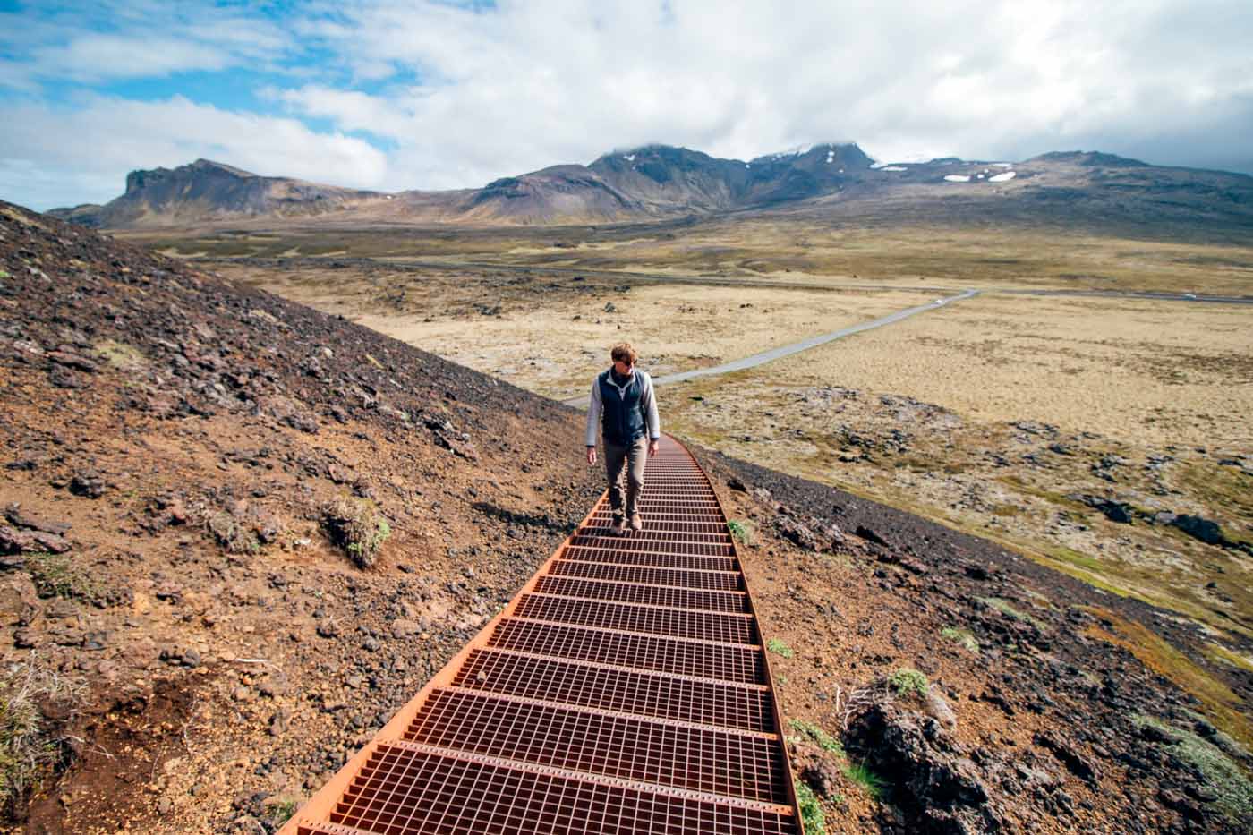
Saxholl Crater
A walk to the top of this 3,000 year-old volcanic crater will give you a 360-degree view of the surrounding area. The crater is about 325 feet high and a spiral staircase built around the side makes for a fairly short climb up to the top.

Djúpalónssandur Black Sand Beach
If the gold beach of Skarðsvík didn’t impress you, then perhaps the black sand beach at Djúpalónssandur will! Sharp, jagged volcanic rock form sea stacks and tide pools. This was one of the starkest looking beaches we visited.
Vatnshellir Cave
Descend down the path of a lava flow that extends nearly 200 meters. This 8000-year-old cave is located in Snaefellsjokull National Park, roughly 10-minutes drive from Hellnar. The cave can only be accessed via a tour, which you can book online or at the visitor center.

Lóndrangar Cliffs
These unique formed basalt dikes rise up from the ocean cliffs, like watchtowers. They are in fact the ancient remains of a crater that has been eroded to its current form by the sea.
Hike from Arnarstapi to Hellnar
If the weather is fair, you might consider the 3-mile round trip hike between Arnarstapi and Hellnar. The short yet scenic walk will take you along the rugged coastline. Jagged basalt cliffs, wave-battered inlets, and sea arches. This is also a great hike if you are interested in seeing some of the many nesting seabirds.
Gatklettur (“Hellnar Arch”)
The hike between Arnsarstapi and Hellnar is the best way to see Gatklettur – otherwise known as Hellnar Arch. Rising from the ocean, the strange swirling sea arch makes for a fantastic photo subject – especially around twilight.

Rauðfeldsgjá Gorge
Otherwise known as the Red Mountain Rift, the Rauðfeldsgjá Gorge is a beautiful ravine located near Botnsfjall Mountain. Sea birds circled high above in the cliffs as we approached the narrow entrance. Following the stream, we made our way a few turns into the ravine without getting too wet. This brought us to a small waterfall inside. To explore deeper, you would need waterproof boots and a willingness to get really wet (we had neither).
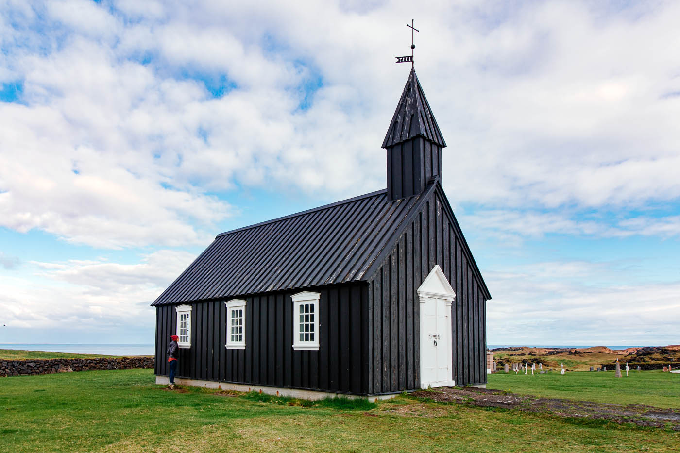
Búðakirkja Black Church
This tiny chapel on the south side of the Snaefellsnes Peninsula is notable for being painted entirely black. There is no nearby town, which makes for a strange juxtaposition against the looming mountains.
Bjarnarfoss
Bjarnarfoss waterfall is located right off of Route 54, yet sees very few tourists. This might be since a short hike/scramble is required to see it. You can see it from the road, but it is definitely worth a closer look.

Gerðuberg Cliffs
A row of perfectly shaped hexagonal basalt columns, the Gerðuberg Cliffs run along the southern side of the Snaefellsnes Peninsula.
Final Thoughts
If you only have a few days to explore Iceland or want to extend your Ring Road experience, then you should definitely spend some time out on the Snaefellsnes Peninsula. See all of Iceland’s natural wonders in one place and get a real feeling of remote desolation (an essential part of the overall Iceland experience!) – all just a 2-hour drive from Reykjavik.
If you’re only going to be in Iceland for a few days and toying between doing the Golden Circle or visiting Snaefellsnes Peninsula, we would vote for Snaefellsnes. It is far less touristy, more visually diverse, and felt like more of an authentic and well-rounded representation of Iceland.
I feel like I know everything about camping and backpacking after looking at your site. I will have to try some of those delicious recipes too!